9.1.4 Radar
Wind Profiler
Operating
characteristics of three common types of radar wind profilers are given in Table
9-3. The categories included in the table are: 1) very high frequency (VHF)
profilers that operate at frequencies near 50 MHZ; 2) ultra-high frequency
(UHF) tropospheric profilers that operate
at frequencies near 400 MHZ; and 3) UHF lower tropospheric profilers that
operate at frequencies near 1000 MHZ. The
guidance provided herein is intended for radar wind profilers that
fall into the third category; i.e., UHF lower tropospheric profilers (also
called boundary layer radar wind
profilers).
Doppler
radar wind profilers operate using principles similar to those used by
Doppler sodars, except that electromagnetic (EM) signals are used rather
than acoustic signals to remotely sense winds aloft. Figure 9-3 shows an
example of the geometry of a UHF radar wind profiler equipped
with a RASS unit (see Section 9.1.5). In this illustration, the radar can
sample along each of five beams: one is
aimed vertically to measure vertical velocity, and four are tilted off vertical and oriented orthogonal to one another
to measure the horizontal components of the air's motion.
A UHF profiler includes subsystems to control the radar's transmitter,
receiver, signal processing, and RASS (if
provided), as well as data telemetry and remote control.
Detailed
information on profiler operation can be found in references [73] and
[74]; a brief summary of the
fundamentals is provided in the following. The radar transmits an electromagnetic
pulse along each of the antenna's pointing directions. The duration of the transmission determines the length of the pulse
emitted by the antenna, which in turn corresponds to
the volume of air illuminated (in electrical terms) by the radar beam. Small
amounts of the transmitted energy are
scattered back (referred to as backscattering) toward and received by the radar. Delays of fixed intervals are built into
the data processing system so that the radar receives
scattered energy from discrete altitudes, referred to as range gates. The
Doppler frequency shift of the
backscattered energy is determined, and then used to calculate the velocity of the air toward or away from the radar along
each beam as a function of altitude. The source of the
backscattered energy (radar targets) is small-scale turbulent
fluctuations that induce irregularities
in the radio refractive index of the atmosphere. The radar is most sensitive
to scattering by turbulent eddies whose
spatial scale is ½ the wavelength of the radar, or approximately
16 centimeters (cm) for a UHF profiler.
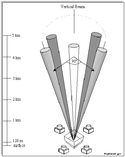
Figure 9-3 Schematic of smapling geometry for
a radar wind profiler with RASS
A
profiler's (and sodar's) ability to measure winds is based on the assumption
that the turbulent eddies that induce scattering are carried along by the
mean wind. The energy scattered by these eddies and received by the profiler
is orders of magnitude smaller than the energy transmitted. However, if
sufficient samples can be obtained, then the amplitude of the energy scattered
by these eddies can be clearly identified above the background noise level,
then the mean wind speed and direction
within the volume being sampled can be determined.
The
radial components measured by the tilted beams are the vector sum of the
horizontal motion of the air toward or away from the radar and any vertical
motion present in the beam. Using
appropriate trigonometry, the three-dimensional meteorological velocity
components (u,v,w) and wind speed and
wind direction are calculated from the radial velocities with corrections
for vertical motions. A boundary-layer radar wind profiler can be configured
to compute averaged wind profiles for
periods ranging from a few minutes to an hour.
Boundary-layer
radar wind profilers are often configured to sample in more than one mode.
For example, in a low mode, the pulse of energy transmitted by the
profiler may be 60 m in length. The pulse
length determines the depth of the column of air being sampled and thus the
vertical resolution of the data. In a high mode, the pulse length is
increased, usually to 100 m or greater.
The longer pulse length means that more energy is being transmitted for each sample, which improves the signal-to-noise ratio
(SNR) of the data. Using a longer pulse length increases
the depth of the sample volume and thus decreases the vertical resolution in
the data. The greater energy output of
the high mode increases the maximum altitude to which the radar wind
profiler can sample, but at the expense of coarser vertical resolution and
an increase in the altitude at which the first winds are measured. When
radar wind profilers are operated in multiple
modes, the data are often combined into a single overlapping data set to
simplify post-processing and data validation procedures.
9. UPPER-AIR MONITORING
9.1 Fundamentals
9.1.1 Upper-Air Meteorological Variables
9.1.2 Radiosonde Sounding System
9.1.3 Doppler Sodar
9.1.4 Radar Wind Profiler
9.1.5 RASS
9.2 Performance Characteristics
9.2.1 Definition of Performance Specifications
9.2.2 Performance Characteristics of Radiosonde Sounding Systems
9.2.3 Performance Characteristics of Remote Sensing Systems
9.3 Monitoring Objectives and Goals
9.3.1 Data Quality Objectives
9.4 Siting and Exposure
9.5 Installation and Acceptance Testing
9.6 Quality Assurance and Quality Control
9.6.1 Calibration Methods
9.6.2 System and Performance Audits
9.6.3 Standard Operating Procedures
9.6.4 Operational Checks and Preventive Maintenance
9.6.5 Corrective Action and Reporting
9.6.6 Common Problems Encountered in Upper-Air Data Collection
9.7 Data Processing and Management (DP&M)
9.7.1 Overview of Data Products
9.7.2 Steps in DP&M
9.7.3 Data Archiving
9.8 Recommendations for Upper-Air Data Collection


