9.3.1 Data
Quality Objectives
Inherent
in any measurement program is the need to establish data quality objectives.
These relate the quality of measurements
obtained to the level of uncertainty that decision makers are
willing to accept in the data and results derived from the data [65].
Data quality objectives state how
good the data need to be to satisfy the program objectives. The stated
objectives generally include
completeness, systematic difference, and comparability. Operators of the instruments should let the data quality
objectives be determined based on instrument performance
specifications and modeling and analysis needs. Data quality objectives
should be specified for all of the
primary variables measured by the instrument.
To
check whether or not the data meet the data quality objectives from an
instrument performance perspective, a
comparison to another sensor that is known to be operating properly is
recommended (see Section 9.5). In assessing how well the sensors compare,
the systematic difference and the
operational comparability can be computed and compared to the data quality objectives that are presented in Table 9-4.
In
evaluating the sodar and radar wind profiler data, the primary criteria for
comparison are the component data; the vector wind speed and wind direction
are secondary. The indicated values for u
and v for the sodar and radar wind profiler in Table 9-4 refer to the
components along the antenna axes, and
for these instruments, the component comparisons should be performed
using calculated values along the antenna axes. Values along the
meteorological axes (north/south and
east/west) should only be used if evaluating a radiosonde. For the sodar and radar wind profiler, the data quality objective
for the vector wind speed and wind direction comparisons
should be applied when winds are greater than 2 to 3 ms -1 . Note
that the values presented in Table 9-5
are based on a number of studies and were reviewed by several measurement
experts participating in an EPA-sponsored workshop on upper-air measurement systems.
Table
9-4
Suggested Data quality objectives for upper-air measurement systems.
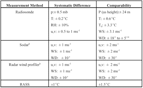
a Over a WS range from 3 to 21ms-1
b For wind speeds greater than approximately 2ms-1
Comparison
results in excess of the data quality objectives do not necessarily mean
that the data are invalid. In making this assessment, it is important to
understand the reasons for the differences.
Reasons may include unusual meteorological conditions, differences due to problems in one or both instruments, or
differences due to sampling techniques and data reduction
protocols. Both the reasons for and the magnitude of the differences, as
well as the anticipated uses of the data,
should be considered in determining whether the data quality objectives
are met. This assessment should be part of the QA protocol.
Data
completeness for radiosonde sounding systems is usually not significantly
affected by outside environmental
conditions such as high winds, precipitation, or atmospheric stability. However, environmental factors can have a
significant effect on the rate of data capture for remote
sensing systems.
9. UPPER-AIR MONITORING
9.1 Fundamentals
9.1.1 Upper-Air Meteorological Variables
9.1.2 Radiosonde Sounding System
9.1.3 Doppler Sodar
9.1.4 Radar Wind Profiler
9.1.5 RASS
9.2 Performance Characteristics
9.2.1 Definition of Performance Specifications
9.2.2 Performance Characteristics of Radiosonde Sounding Systems
9.2.3 Performance Characteristics of Remote Sensing Systems
9.3 Monitoring Objectives and Goals
9.3.1 Data Quality Objectives
9.4 Siting and Exposure
9.5 Installation and Acceptance Testing
9.6 Quality Assurance and Quality Control
9.6.1 Calibration Methods
9.6.2 System and Performance Audits
9.6.3 Standard Operating Procedures
9.6.4 Operational Checks and Preventive Maintenance
9.6.5 Corrective Action and Reporting
9.6.6 Common Problems Encountered in Upper-Air Data Collection
9.7 Data Processing and Management (DP&M)
9.7.1 Overview of Data Products
9.7.2 Steps in DP&M
9.7.3 Data Archiving
9.8 Recommendations for Upper-Air Data Collection


