9.5 Installation and Acceptance Testing
This
section provides guidance for the installation and acceptance testing of
upper-air monitoring systems; similar guidance for in situ sensors is
provided in Section 8.2
The
installation period is the optimal time to receive appropriate training in
instrument principles, operations, maintenance, and troubleshooting, as well
as data interpretation and validation.
Meteorological consultants as well as some manufacturers and vendors of meteorological instruments provide these
services.
Installation
procedures specific to upper-air monitoring systems include the following:
- The
latitude, longitude, and elevation of the site should be determined
using U.S. Geological Survey (USGS) topographical maps, other detailed
maps, or a GPS instrument.
- The
orientation of antennas of the sodar, radar profiler, or radio
theodolite systems should be defined
with respect to true north. One recommended method is to use the solar
siting technique [2] . This
technique enables determination of true north at any location using a compass (or other pointing device suitable
for measuring the azimuth angle to the sun), a computer
program, the site latitude and longitude, and accurate local time.
- The
site should be documented as follows:
- Photographs
in sufficient increments to create a documented 360°
panorama around the antennas
should be taken. Additionally, pictures of the antenna installation,
shelter and any obstacles that could influence the data should be obtained.
- Photographs
of the instrument, site, shelter, and equipment and computers inside the
shelter should be obtained.
- A
detailed site layout diagram that identifies true north and includes the
locations of the instrument, shelter, other equipment, etc. should be
prepared. An example of such a
diagram is shown in Figure 9-4. Additionally, it is recommended that the site layout diagram include the
electrical and signal cable layout, and the beam directions
of any remote sensor.
- A
vista table that documents the surroundings of the site in 30_
increments should be prepared. Vistas for the beam directions, if
they are not represented by the 30°
views (±5°),
should be included. The table should identify any potential passive and active noise sources in each direction,
and the approximate distance and elevation angle above the horizon to
the objects. An example is shown in Table 9-5.
An
acceptance test is used to determine if an instrument performs according to
the manufacturer's specifications [2]. Manufacturer's procedures for
unpacking, inspection, installation, and system diagnostics
should be followed to assure that all components are functioning
appropriately. All acceptance-testing
activities should be documented in the station log. Once
the system is installed, a final field check is needed to assure that the
data are reasonable. This is best performed using collocated meteorological
information from towers or other
upper-air sensors. In the absence of these data sources, nearby upper-air
data from the NWS radiosonde network, the NOAA profiler network, aircraft
reports, National Center for Environmental Prediction (NCEP) high resolution
mesoscale analyses, or other upper-air data can be used. It is important to
have an individual trained in the interpretation of the data perform a
thorough review of at least several days of data. This check is not meant to
evaluate whether or not the data meet the manufacturer's data
specifications, but is intended to identify problems such as:
- Component
failures
- Incorrect
or improper operating/sampling parameters
- Antenna
azimuth angles specified improperly or incorrectly measured
- Siting
problems (active and passive interfering noise sources)
Shortly
after the installation and startup of an instrument, a system and
performance audit should be performed. These audits will provide information
for the qualitative and quantitative assessment
of the performance of the system, as well as the adequacy of the standard
operating procedures used for collection,
processing, and validation of the data. To best assure that the data
collected is of known quality, and that potential problems are identified
early, it is recommended the initial
audit be performed within 30 days of the start-up date.
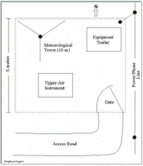
Figure 9-4 Example Site Layout diagram
9. UPPER-AIR MONITORING
9.1 Fundamentals
9.1.1 Upper-Air Meteorological Variables
9.1.2 Radiosonde Sounding System
9.1.3 Doppler Sodar
9.1.4 Radar Wind Profiler
9.1.5 RASS
9.2 Performance Characteristics
9.2.1 Definition of Performance Specifications
9.2.2 Performance Characteristics of Radiosonde Sounding Systems
9.2.3 Performance Characteristics of Remote Sensing Systems
9.3 Monitoring Objectives and Goals
9.3.1 Data Quality Objectives
9.4 Siting and Exposure
9.5 Installation and Acceptance Testing
9.6 Quality Assurance and Quality Control
9.6.1 Calibration Methods
9.6.2 System and Performance Audits
9.6.3 Standard Operating Procedures
9.6.4 Operational Checks and Preventive Maintenance
9.6.5 Corrective Action and Reporting
9.6.6 Common Problems Encountered in Upper-Air Data Collection
9.7 Data Processing and Management (DP&M)
9.7.1 Overview of Data Products
9.7.2 Steps in DP&M
9.7.3 Data Archiving
9.8 Recommendations for Upper-Air Data Collection


