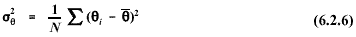
6.2.1 Scalar Computations
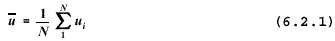
The
scalar mean wind speed is:
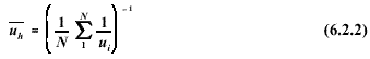
The
harmonic mean wind speed is:
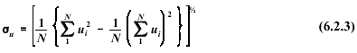
The
standard deviation of the horizontal component of the wind speed is:
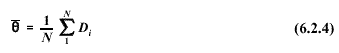
The
wind direction is a circular function with values between l and 360 degrees.
The wind direction discontinuity at the beginning/end of the scale requires
special processing to compute a valid mean value. A single-pass procedure
developed by Mitsuta and documented in reference [23] is recommended.
The method assumes that the difference between successive wind direction
samples is less than 180 degrees; to ensure such, a sampling rate of once
per second or greater should be used (see Section 6.2.4). Using the Mitsuta
method, the scalar mean wind direction is computed as:
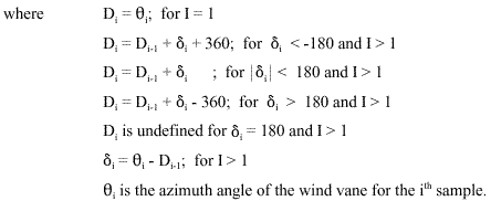
The
following notes/cautions apply to the determination of the scalar mean wind
direction using Equation. 6.2.4:
- If
the result is less than zero or greater than 360, increments of 360
degrees should be added or subtracted, as appropriate, until the result
is between zero and 360 degrees.
- Erroneous
results may be obtained if this procedure is used to post-process
sub-hourly averages to obtain an hourly average. This is because there
can be no guarantee that the difference between successive sub-hourly
averages will be less than 180 degrees.
The
scalar mean wind direction, as defined in Equation. 6.2.4, retains the
essential statistical property of a mean value, namely that the deviations
from the mean must sum to zero:

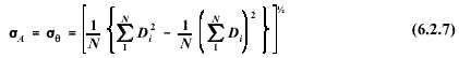
By
definition, the same mean value must be used in the calculation of the
variance of the wind direction and, likewise, the standard deviation (the
square root of the variance). The variance of the wind direction is given
by:
The
standard deviation of the wind direction using the Mitsuta method is given
by:
Cases
may arise in which the sampling rate is insufficient to assure that
differences between successive wind direction samples are less than 180
degrees. In such cases, approximation formulas may be used for computing the
standard deviation of the wind direction. Mardia [24] shows that a
suitable estimate of the standard deviation (in radian measure) is:

Several
methods for calculating the standard deviation of the wind direction were
evaluated by Turner [25]; a method developed by Yamartino [26] was
found to provide excellent results for
most cases. The Yamartino method is given in the following:


Note
that hourly _ _ values
computed using 6.2.7, 6.2.8, or 6.2.9 may be inflated by contributions from
long period oscillations associated with light wind speed conditions (e.g.,wind
meander). To minimize the effects of wind meander, the hourly  (for use e.g., in stability determinations - see Section 6.4.4.4)
should be calculated based on four 15-minute values averaged as follows:
(for use e.g., in stability determinations - see Section 6.4.4.4)
should be calculated based on four 15-minute values averaged as follows:

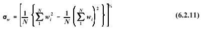
The
standard deviation of the vertical component of the wind speed is:
Similarly,
the standard deviation of the elevation angle of the wind vector is:
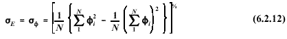
Equation
6.2.12 is provided for completeness only. The bivane, which is used to
measure the elevation angle of the wind, is regarded as a research grade
instrument and is not recommended for routine monitoring applications. See
Section 6.2.3 for recommendations on estimating .
.
6. METEOROLOGICAL DATA PROCESSING
6.1 Averaging and Sampling Strategies
6.2 Wind Direction and Wind Speed
6.2.1 Scalar Computations
6.2.2 Vector Computations
6.2.3 Treatment of Calms
6.2.4 Turbulence
6.2.5 Wind Speed Profiles
6.3 Temperature
6.3.1 Use in Plume-Rise Estimates
6.3.2 Vertical Temperature Gradient
6.4 Stability
6.4.1 Turner's method
6.4.2 Solar radiation/delta-T (SRDT) method
6.4.3
 E method
6.4.4 Amethod
6.4.5 Accuracy of stability category estimates
6.5 Mixing Height
6.5.1 The Holzworth Method
6.6 Boundary Layer Parameters
6.6.1 The Profile Method
6.6.2 The Energy Budget Method
6.6.3 Surface Roughness Length
6.6.4 Guidance for Measurements in the Surface Layer
6.7 Use of Airport Data
6.8 Treatment of Missing Data
6.8.1 Substitution Procedures
6.9 Recommendations


