6.6.3 Surface Roughness Length
The
roughness length (z0 ) is related to the roughness
characteristics of the terrain. Under near-neutral
conditions and with a homogeneous distribution of obstacles, a local value
of z0 can be determined from the logarithmic wind profile.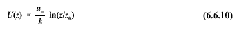
For
general application, since typical landscapes almost always contain
occasional obstructions, one should
attempt to estimate an effective roughness length. The recommended method
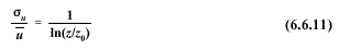
for estimating the effective roughness length is based on single level
gustiness measurements  u
[60]:
u
[60]:
Wind
measurements for use in (6.6.11) should be made between 20 z0 and
100 z0 ; toselect the
appropriate measurement level, an initial estimate of the effective
roughness length must first be made based on a visual inspection of the
landscape (see roughness classifications provided in Table 6-10). The
sampling duration for u
and should be between 3 and 60 u minutes. Data collected for use in
estimating the effective surface roughness should be stratified by wind
speed (only data for wind speeds greater than 5 m/s should be used) and wind
direction sector (using a minimum sector arc width of 30 degrees). Median z0
values should be computed for each sector; results should then be inspected
to determine whether the variation between sectors is significant. An
average of the median values should be computed for adjacent sectors if the
variation is not significant. Estimates of the effective surface roughness
using these procedures are accurate to one significant figure; i.e., a
computed value of 0.34 m should be rounded to 0.3 m. Documentation of the
successful application of these procedures is provided in reference [61].
Table
6-10
Terrain Classification in Terms of Effective Surface Roughness
Length, ZO |
| Terrain
Description | ZO
(m) |
| Open sea, fetch at least
5km | 0.0002 |
| Open flat terrain; grass,
few isolated obstacles | 0.03 |
| Low crops, occasional
large obstacles; x'/h > 20* | 0.10 |
| High crops, scattered
obstacles, 15 < x'/h < 20* | 0.25 |
| Parkland, bushes, numerous
obstacles, x'/h 10* | 0.50 |
| Regular large obstacle
coverage (suburb, forest) | 0.50 - 1.0 |
6. METEOROLOGICAL DATA PROCESSING
6.1 Averaging and Sampling Strategies
6.2 Wind Direction and Wind Speed
6.2.1 Scalar Computations
6.2.2 Vector Computations
6.2.3 Treatment of Calms
6.2.4 Turbulence
6.2.5 Wind Speed Profiles
6.3 Temperature
6.3.1 Use in Plume-Rise Estimates
6.3.2 Vertical Temperature Gradient
6.4 Stability
6.4.1 Turner's method
6.4.2 Solar radiation/delta-T (SRDT) method
6.4.3
E method
6.4.4 Amethod
6.4.5 Accuracy of stability category estimates
6.5 Mixing Height
6.5.1 The Holzworth Method
6.6 Boundary Layer Parameters
6.6.1 The Profile Method
6.6.2 The Energy Budget Method
6.6.3 Surface Roughness Length
6.6.4 Guidance for Measurements in the Surface Layer
6.7 Use of Airport Data
6.8 Treatment of Missing Data
6.8.1 Substitution Procedures
6.9 Recommendations


