6.6.1 The
Profile Method
The
bulk Richardson number given in (6.6.3) is perhaps the simplest and most
direct approach for characterizing the surface layer. For example, given the
necessary surface layer measurements, one can derive both H and u* from the
integrated flux-profile equations: [51,52]
where
 R is a parameter
associated with the empirically determined similarity functions,
R is a parameter
associated with the empirically determined similarity functions,  m and
h .
The U.S. EPA recommends using the empirical functions given in reference [59];
in this case the von Karman constant, k = 0.4 and R = 1. The temperature
scale
m and
h .
The U.S. EPA recommends using the empirical functions given in reference [59];
in this case the von Karman constant, k = 0.4 and R = 1. The temperature
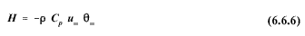
scale  * is related to the
heat flux by:
* is related to the
heat flux by:
Methods
for solving the flux profile equations vary depending on what measurements
are available. In the general case with
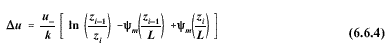
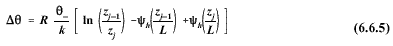
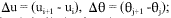
two arbitrary levels each of temperature and wind speed [i.e., as in (6.6.4)
and (6.6.5) ], one can solve for the unknowns (u* ,
* , and L) by iteration; when temperature and wind speed are measured
at the same heights, approximate analytic solutions can be used.
Other
simplifications result by replacing the lower wind speed measurement height
in (6.6.4), zi , with the surface roughness length (z0 ) [51,52] ;
see Section 6.6.3 for guidance on estimating surface roughness. A least
squares method [49] is recommended when wind speed and temperature
data are available for three or more levels. To ensure the data are
representative of the surface layer, the wind speed and temperature sensors
should be located between 20z0 and 100z0 ; for sites with very low
roughness, the sensors should be located between 1 and 10 m. Sampling
durations for use in computing 1-hour averages should be in the range of 3
to 60 minutes; a sampling duration of 15 minutes or less is recommended if
the steady-state assumption is in doubt.
6. METEOROLOGICAL DATA PROCESSING
6.1 Averaging and Sampling Strategies
6.2 Wind Direction and Wind Speed
6.2.1 Scalar Computations
6.2.2 Vector Computations
6.2.3 Treatment of Calms
6.2.4 Turbulence
6.2.5 Wind Speed Profiles
6.3 Temperature
6.3.1 Use in Plume-Rise Estimates
6.3.2 Vertical Temperature Gradient
6.4 Stability
6.4.1 Turner's method
6.4.2 Solar radiation/delta-T (SRDT) method
6.4.3
 E method
6.4.4 Amethod
6.4.5 Accuracy of stability category estimates
6.5 Mixing Height
6.5.1 The Holzworth Method
6.6 Boundary Layer Parameters
6.6.1 The Profile Method
6.6.2 The Energy Budget Method
6.6.3 Surface Roughness Length
6.6.4 Guidance for Measurements in the Surface Layer
6.7 Use of Airport Data
6.8 Treatment of Missing Data
6.8.1 Substitution Procedures
6.9 Recommendations


